

GNSS
Where you are and which satellites you can see, from the Cap's receiver, with Tracks saved to the SD card as GPX.
GNSS needs the Cap LoRa-1262, an antenna with a view of the sky, and Settings → GNSS switched On. Otherwise the App says GNSS is off (or paused, when "Pause GNSS for LoRa" has put the receiver on standby while the radio listens). A first fix outdoors can take a while: the App says how long it has been searching.
Position
The first view shows the fix (No Fix, 2D Fix or 3D Fix, and how many satellites it uses), then:
- Lat and Lon, in decimal degrees or degrees, minutes and seconds (Settings → Coordinates);
- the Locator, the Maidenhead grid square;
- Altitude, Speed and the direction you are moving;
- HDOP, the horizontal precision: a smaller number is better;
- the Time, in UTC.
Once there is a fix, the device's clock follows it.
Sky
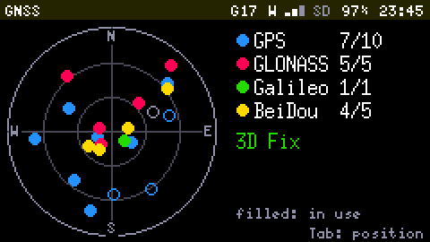
Tab switches between Position and Sky: a circle with N, E, S and W, where each satellite is a dot, coloured by constellation, and filled when the receiver uses it. A legend counts, for each constellation (GPS, GLONASS, Galileo, BeiDou), the satellites used and in view.
Tracks
r starts recording a Track: the route is saved as a GPX file on the SD card, in /gnss/tracks (named by date and time), and the Status Bar shows REC. Press r again to stop. A Track keeps recording with the App closed. It needs a card and a clock (a fix or Wi-Fi sets it); if it cannot start, the App says why: GNSS is off, No SD card or Waiting for the time. The Storage App opens a .gpx file and shows its points, start, duration and distance.